
Blue Island ZIP Coverage
Official sources inspected for the Blue Island ZIP code directory support 60406 as the city’s delivery ZIP. It appears in USPS tools and on official city and library addresses. No second ZIP serving an incorporated Blue Island address was confirmed. That careful statement matters because a postal city label may reach beyond the incorporated line, while some municipal-edge parcels can require address-level checking.
| ZIP Code | Areas Covered | Post Office | Notes |
|---|---|---|---|
| 60406 | Blue Island delivery addresses verified one address at a time | No named station confirmed in inspected USPS result | Postal labeling is not a city-boundary ruling |
No official Blue Island station polygon, PO-box-only ZIP, unique institutional ZIP, population table, or historic split date was located. Those gaps should stay visible. For a specific house, USPS is the postal authority, CookViewer supplies parcel geometry, and city Planning or the Clerk can address municipal limits. The table therefore reports only what the sources establish, rather than turning a third-party ZIP map into an official boundary.
Search Blue Island USPS Fields
The USPS ZIP Code Lookup has three distinct paths. By Address is the best path for one parcel because it can return the delivery ZIP and recognized city label. By City and State returns ZIPs tied to the city label, not the city’s legal footprint. Cities by ZIP reverses that question and lists city names recognized for a supplied ZIP.
| USPS path | Fields in order | Useful result |
|---|---|---|
| By Address | Company optional; street required; unit optional; city; state; ZIP optional | Exact delivery form and ZIP |
| By City and State | City; state | ZIPs associated with that postal city label |
| Cities by ZIP | Five-digit ZIP | Recognized city names served by the ZIP |
USPS warns that a result does not confirm a person or organization at an address. A unit may be needed to narrow a multi-unit property. Copy the standardized street form and ZIP exactly, then use the county portal’s own fields.
The first assigned capture shows the official USPS lookup choices used by this Blue Island ZIP code directory.
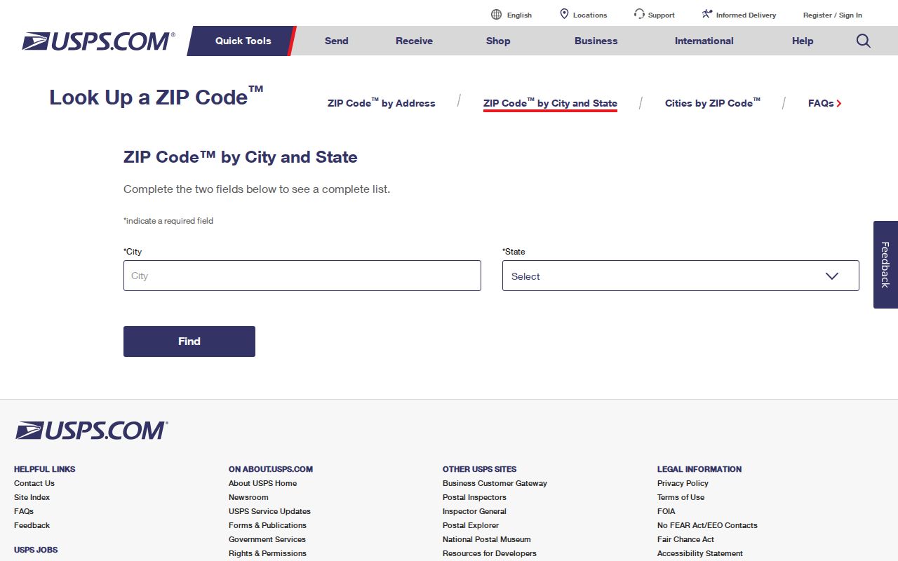
The tabs separate an exact delivery-address check from broader city-label and ZIP-label questions, which prevents a postal result from being mistaken for a resident roll.
Blue Island ZIP Portal Differences
Cook County and Illinois systems do not share one ZIP field. The Treasurer accepts ZIP as an optional part of an address search. Illinois voter verification requires a five-digit ZIP before its dynamic street step. Illinois I-Cash accepts ZIP as an optional filter beside a name and property ID. By contrast, the Assessor address path and CookViewer do not expose a ZIP control in the inspected forms.
| Official portal | ZIP control | What the result means |
|---|---|---|
| USPS | Required for Cities by ZIP; optional by address | Postal label or delivery result, not a person match |
| Cook County Treasurer | Optional address ZIP | Parcel, tax, and mailing fields for a matched property |
| Illinois voter lookup | Required five-digit ZIP | Personal registration verification, not a public roster |
| Illinois I-Cash | Optional ZIP | Unclaimed-property lead that still requires a claim |
| Assessor and CookViewer | No ZIP field in inspected paths | Address, PIN, township, class, or map-based parcel result |
This mismatch is useful. If 60406 narrows a Treasurer query but the Assessor search fails, remove the ZIP and enter the street name in the format the Assessor expects. If parcel geometry matters, switch to CookViewer with the address, 14-digit PIN, or intersection.
The second successful capture comes from the Cook County Property Tax Portal, where a ZIP can assist an address search.
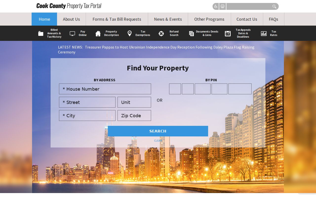
The portal’s result remains a property and tax record. Its mailing field does not show who occupies the Blue Island parcel today.
Note: A ZIP filter may reduce results, but the parcel PIN is the stronger key when county portals disagree about an address.
Find Blue Island Residents by ZIP
A Blue Island ZIP code directory can narrow a search, but the next step depends on what is known. Use USPS to validate the postal field. Then choose a property, voter, unclaimed-property, court, or historical source based on the question. No inspected official tool returned a public list of all people in 60406.
- Run USPS By Address with the full street and unit, then copy the recognized delivery form.
- Use the Treasurer’s optional ZIP to narrow the property address, or search the Assessor without ZIP.
- Open CookViewer by address or PIN to confirm parcel geometry and the city-limit context.
- Use the Illinois voter lookup only for personal registration verification with the required identity facts.
- Move to a name-based official record and confirm it with a second independent attribute.
Once the postal search reaches a named road, the Blue Island street directory carries the work through address, parcel, deed, and historical street records. That handoff keeps the ZIP code directory focused on postal geography instead of rebuilding a street-by-street chain.
Five Blue Island Address Identities
A Blue Island address can have five official identities. Postal identity comes from USPS. Parcel identity comes from CookViewer geometry and the 14-digit PIN. Tax identity includes the Treasurer’s tax code and billing address. Legal identity appears in recorded documents through a subdivision, block, lot, or section-township-range description. Historical identity may live in the 1929 address table, a directory, Sanborn map, newspaper, or preservation file.
These keys answer different questions. A tax-bill mailing address can belong to a recipient away from the parcel. A USPS city label can cross a municipal line. A deed can preserve a legal description after a street number changes. The five-identity test is especially useful near annexed ground, planning districts, or a parcel split, where one familiar street label may hide several record systems.
- ZIP+4
- A more precise delivery code for a segment, building, or group of boxes.
- PO-box ZIP
- A ZIP assigned to post-office boxes rather than ordinary street delivery.
- Unique ZIP
- A ZIP assigned to one large organization; none was verified for Blue Island.
- Carrier route
- A mail-delivery path within a ZIP, not a city or parcel boundary.
Historic Blue Island ZIP Searches
An address printed before modern ZIP use cannot be pushed straight into USPS. Blue Island has a specific bridge: the Historical Society’s digitized 1929 revised street-address and name table. It can show a number change, a street-name change, or both. One documented W 119th Place sequence changes old 308 to new 2046, old 299 to new 2050, and old 298 to new 2051.
Start with the directory edition and page, translate the address through that table, then test the current form in USPS. Follow with CookViewer, Assessor, Treasurer, and the recorded-document index. The conversion row does not identify a resident, and a modern ZIP should not be projected backward without proof. Old local phone books, directories, Sanborn maps, and newspapers can place an address in its own time.
Blue Island ZIP Research Contacts
No official Blue Island ZIP boundary or realignment map was found in the inspected sources. When an exact address fails, use the channel that controls the disputed fact. USPS handles delivery designations. City Planning, Public Works, or the Clerk can address a municipal street or city-limit question. Cook County GIS and Clerk maps control parcel geometry, while library and archive sources explain older street forms.
USPS Lookup
Use the web tabs first, then ask USPS address management about an unresolved delivery form.
Cook County GIS
Use CookViewer or contact gis@cookcountyil.gov for parcel geometry and map questions.
Blue Island Offices
Ask Planning, Public Works, or the City Clerk about civic addresses and municipal limits.
A narrow Illinois FOIA request can seek a dated city or county GIS layer when the public viewer does not answer a boundary question. It cannot change a USPS delivery designation. For old geography, the Blue Island Public Library and Historical Society are the better channels.
Cook County also offers help when a map cannot settle the issue. GIS questions can go to gis@cookcountyil.gov, while Clerk maps can be reached at 312-603-5640. A useful inquiry includes the full address, current PIN if known, the portal already checked, and the date of the disputed source. Keep a USPS answer separate from the county reply. For a city-limit question, ask Blue Island staff for a dated municipal map or annexation record. Clear source labels keep one boundary system from being mistaken for another.
Blue Island ZIPs Versus City Limits
A ZIP is a delivery geography. Blue Island’s incorporated boundary, wards, precincts, townships, school districts, tax codes, and parcel lines are separate systems. The inspected sources did not prove a specific 60406 exception or a second city ZIP, so an exact address must be checked rather than assigned from a generalized map.
Use Cities by ZIP to learn which postal city labels USPS recognizes, then use By Address for the exact street and unit. Compare the returned label with CookViewer and a current city map. Preserve any mismatch as a finding. Do not silently “correct” the postal city to match the municipality, and do not treat the city label as proof that a person lives inside Blue Island.
Boundary rule. The Blue Island ZIP code directory narrows delivery geography; parcel and municipal sources decide other boundaries.
A negative ZIP search also has limits. A street may use the wrong modern form, an apartment may be missing, or a historic number may need conversion. Repeat the query with the exact USPS form, then check the parcel by PIN. If both routes fail, keep the failed terms and contact the right custodian instead of assuming that the address or resident does not exist.